Calendar Icon
Jul 06, 2015
Person Bust Icon
By Karl Vogel
![]() RSS
Submit a Story
RSS
Submit a Story
During a record-breaking two months of rainfall this spring, much of Nebraska kept its eyes on the sky and its ears open for weather alerts about flooding.
While John Stansbury wasn’t out chasing the storms or watching the radar, the associate professor of civil engineering at UNL was interested nonetheless.
"I’m no more interested in going out to see a storm than all the rest of the husbands standing on their front porches,” said Stansbury, whose research includes best management practices for stormwater management. “The meteorology part has never been something that I’ve gotten into. I’m more interested in the big picture and how it’s going to affect our water resources than I am in any one big storm.”
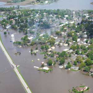
In the days after a May 7 storm dumped up to 11 inches of rain on parts of southeast Nebraska, many communities felt the effects, including flooding in De Witt, Fairbury and McCool Junction.
The relatively new Antelope Valley project in Lincoln saw water levels in the Salt, Oak and Antelope creeks nearly spill over the banks and communities to the north and east, along the path Salt Creek takes as it flows toward the Platte River, experienced some flooding.
 While driving through Ashland in the days after the big storm, Stansbury couldn’t help but take a detour to see how Salt Creek and the Platte River held up.
“It’s a mixture of professional and personal interest, largely personal,” Stansbury said. “I went to Ashland for an entirely different reason and just happened to see the flood go by.
“Certainly, I’m interested in the big events, but I’m more interested in what’s the meaning of all this. Are the climate patterns changing? What effect could that have on our water resources availability? Will we have more water or less water? Will we have more floods or bigger floods we have to engineer around?”
For the most part, Stansbury said, the engineering projects across the eastern part of Nebraska fared very well despite being overwhelmed in places by the record rainfall and residual runoff.
“It’s really hard to take these isolated events and say too much about them because there have always been floods in these basins,” Stansbury said. “We’ve certainly had 11-inch storms before. You want to think there’s something special about these, but it takes a lot of data collected over decades and centuries to make that determination.”
Civil engineers often look at projects in terms of preparing for the “100-year flood or 100-year storm,” Stansbury said. The relative paucity of data, Stansbury said, makes it difficult to know just what that means.
Across the United States, it is only in recent decades that engineers have been able to make those historical analyses with great certainty. That is because weather statistics have only been kept for a little more than the last 100 years. In Lincoln, for example, a University of Nebraska database shows temperature and precipitation records that date to the 1880s.
“When you’re talking about recent, though, you’re talking about a decade or a couple of decades. It’s hard to know if the data you’re collecting is representative of what it’s going to be like or if it’s just a blip in the historical record,” Stansbury said. “In another 100 years, we’ll be able to look back and say that what was going on in 2015 was the start of things that changed or if that just happened to be a wetter-than-normal year in a certain part of Nebraska.”
In the meantime, Stansbury said, engineers have plenty of options available to help communities control flooding and diminish the potential for damage to property – flood-control reservoirs and levees, for example. But none of them, Stansbury said, is fail-safe, as the recent months of rain have shown in Nebraska and the storms of 2011 showed with the flooding along the Missouri River in Nebraska, Iowa and Missouri.
“The tricky thing about those kinds of controls is they have a designed return period that they protect for,” Stansbury said. “We typically design levees, although there's no such thing as typical, to protect for the 100-year flood. On average, that means that 99 years out of 100 years your town shouldn’t get flooded. People forget that that it also means that on average one year out of 100 you will get flooded. Some get upset and say that the flood protection didn’t work, when in reality it probably did work just as it was designed.”
That doesn’t stop engineers like Stansbury from keeping an eye on the weather, even when on vacation. Before heading out on a family vacation, Stansbury admitted that the forecast has piqued his interest.
“My poor wife,” Stansbury said with a chuckle. “She’s suffered through a lot of vacation side trips to go look at watersheds and floods and flood damage.
“We’re going to Colorado, and I see they’re talking about big storms and possible flash floods, so maybe I’ll get to see something. You can’t plan this because you never really know just what’s coming.”
While John Stansbury wasn’t out chasing the storms or watching the radar, the associate professor of civil engineering at UNL was interested nonetheless.
"I’m no more interested in going out to see a storm than all the rest of the husbands standing on their front porches,” said Stansbury, whose research includes best management practices for stormwater management. “The meteorology part has never been something that I’ve gotten into. I’m more interested in the big picture and how it’s going to affect our water resources than I am in any one big storm.”
In the days after a May 7 storm dumped up to 11 inches of rain on parts of southeast Nebraska, many communities felt the effects, including flooding in De Witt, Fairbury and McCool Junction.
The relatively new Antelope Valley project in Lincoln saw water levels in the Salt, Oak and Antelope creeks nearly spill over the banks and communities to the north and east, along the path Salt Creek takes as it flows toward the Platte River, experienced some flooding.
While driving through Ashland in the days after the big storm, Stansbury couldn’t help but take a detour to see how Salt Creek and the Platte River held up.
“It’s a mixture of professional and personal interest, largely personal,” Stansbury said. “I went to Ashland for an entirely different reason and just happened to see the flood go by.
“Certainly, I’m interested in the big events, but I’m more interested in what’s the meaning of all this. Are the climate patterns changing? What effect could that have on our water resources availability? Will we have more water or less water? Will we have more floods or bigger floods we have to engineer around?”
For the most part, Stansbury said, the engineering projects across the eastern part of Nebraska fared very well despite being overwhelmed in places by the record rainfall and residual runoff.
“It’s really hard to take these isolated events and say too much about them because there have always been floods in these basins,” Stansbury said. “We’ve certainly had 11-inch storms before. You want to think there’s something special about these, but it takes a lot of data collected over decades and centuries to make that determination.”
Civil engineers often look at projects in terms of preparing for the “100-year flood or 100-year storm,” Stansbury said. The relative paucity of data, Stansbury said, makes it difficult to know just what that means.
Across the United States, it is only in recent decades that engineers have been able to make those historical analyses with great certainty. That is because weather statistics have only been kept for a little more than the last 100 years. In Lincoln, for example, a University of Nebraska database shows temperature and precipitation records that date to the 1880s.
“When you’re talking about recent, though, you’re talking about a decade or a couple of decades. It’s hard to know if the data you’re collecting is representative of what it’s going to be like or if it’s just a blip in the historical record,” Stansbury said. “In another 100 years, we’ll be able to look back and say that what was going on in 2015 was the start of things that changed or if that just happened to be a wetter-than-normal year in a certain part of Nebraska.”
In the meantime, Stansbury said, engineers have plenty of options available to help communities control flooding and diminish the potential for damage to property – flood-control reservoirs and levees, for example. But none of them, Stansbury said, is fail-safe, as the recent months of rain have shown in Nebraska and the storms of 2011 showed with the flooding along the Missouri River in Nebraska, Iowa and Missouri.
“The tricky thing about those kinds of controls is they have a designed return period that they protect for,” Stansbury said. “We typically design levees, although there's no such thing as typical, to protect for the 100-year flood. On average, that means that 99 years out of 100 years your town shouldn’t get flooded. People forget that that it also means that on average one year out of 100 you will get flooded. Some get upset and say that the flood protection didn’t work, when in reality it probably did work just as it was designed.”
That doesn’t stop engineers like Stansbury from keeping an eye on the weather, even when on vacation. Before heading out on a family vacation, Stansbury admitted that the forecast has piqued his interest.
“My poor wife,” Stansbury said with a chuckle. “She’s suffered through a lot of vacation side trips to go look at watersheds and floods and flood damage.
“We’re going to Colorado, and I see they’re talking about big storms and possible flash floods, so maybe I’ll get to see something. You can’t plan this because you never really know just what’s coming.”
-

With heavy rains in early June, the water in Salt Creek rose to near flood stage for a second time this spring. -

With heavy rains in early June, the water in Salt Creek rose to near flood stage for a second time this spring. -

In early June, Antelope and Salt Creeks are at near flood stage where they meet north of the Devaney Sports Center. -

Antelope Creek, which runs along the west side of the Devaney Sports Center, was at near flood stage for a second time this spring after heavy rains in early June.
Submit a Story