2026 Projects
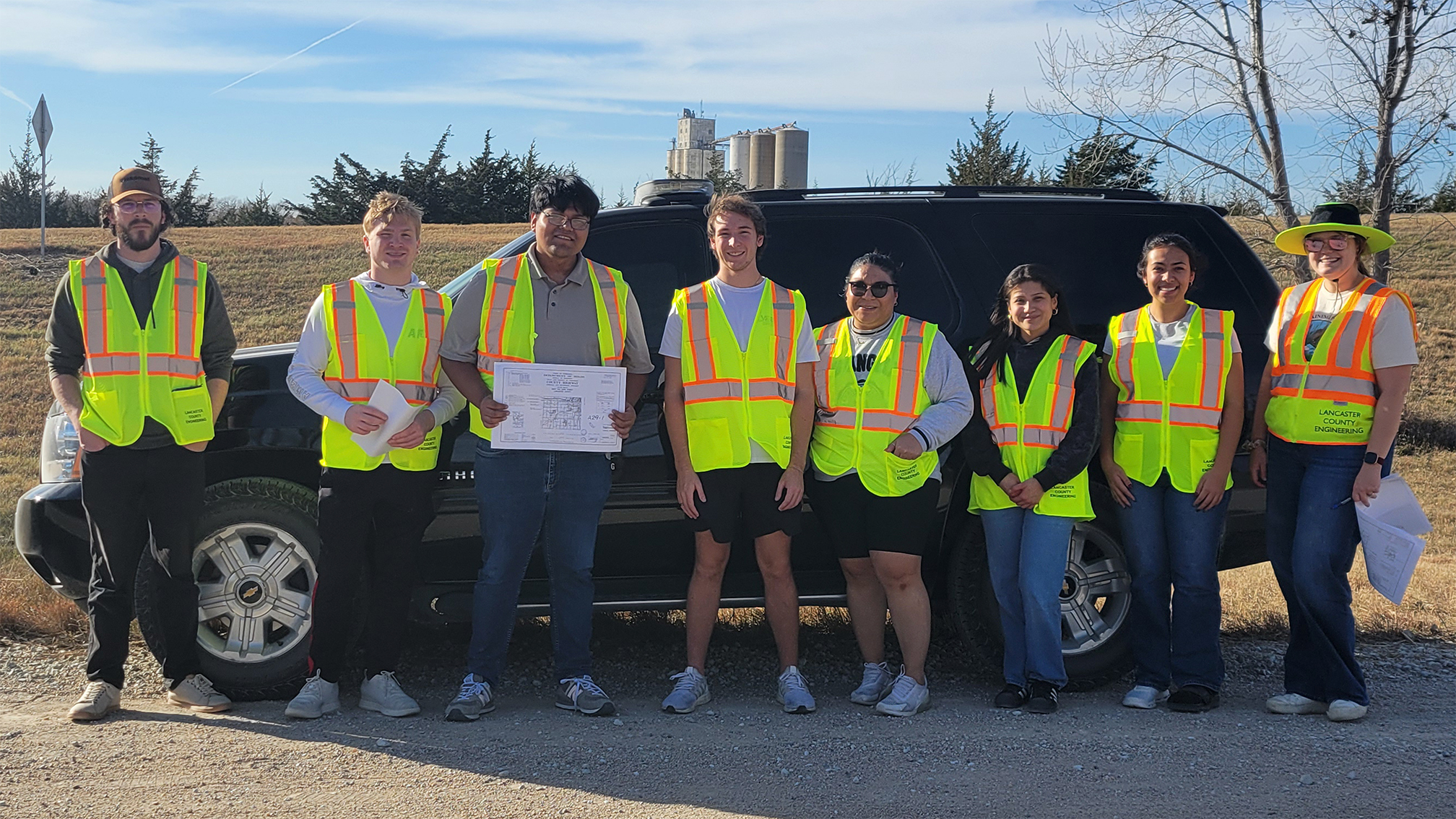
98th and Adams Street Improvement
Team Members
- Jackson Ehlers
- Creighton Blahak
- Matthew Eschenbrenner
- Matthew Ondracek
Project Overview
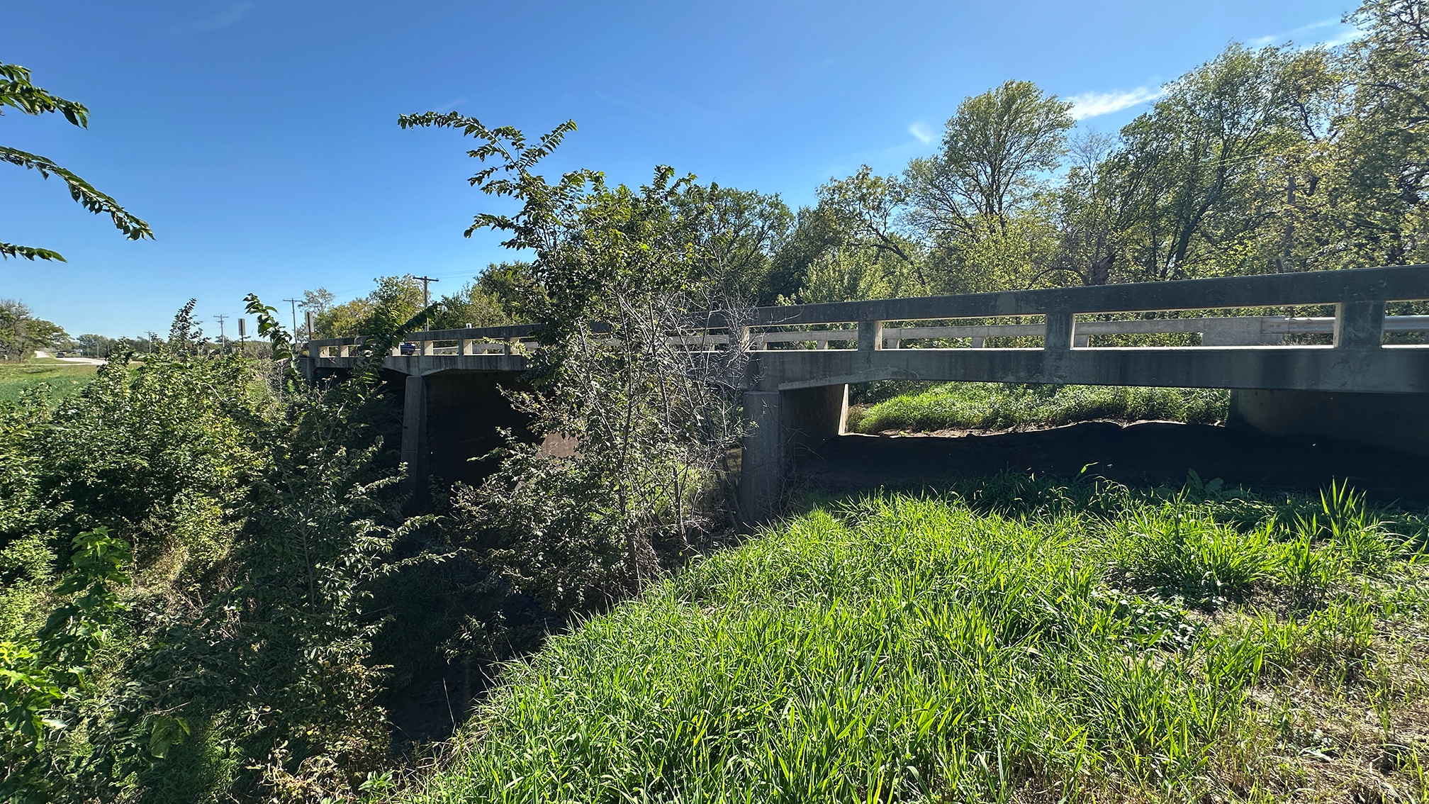
We are the 98th and Adams Improvement team, which we designed on behalf of the Lancaster County Engineers. It involves designing and drafting a new bridge and roadway over the troublesome Stevens Creek floodway, while providing a reasonable solution.
Barn Restoration and Aquatic Habitat Design for Nebraska Wildlife Rehabilitation
Team Members
- John Colt
- Alex Kucera
- Onjoy Mahmood
- Ben McGinnis
- Emilia Wright
Project Overview
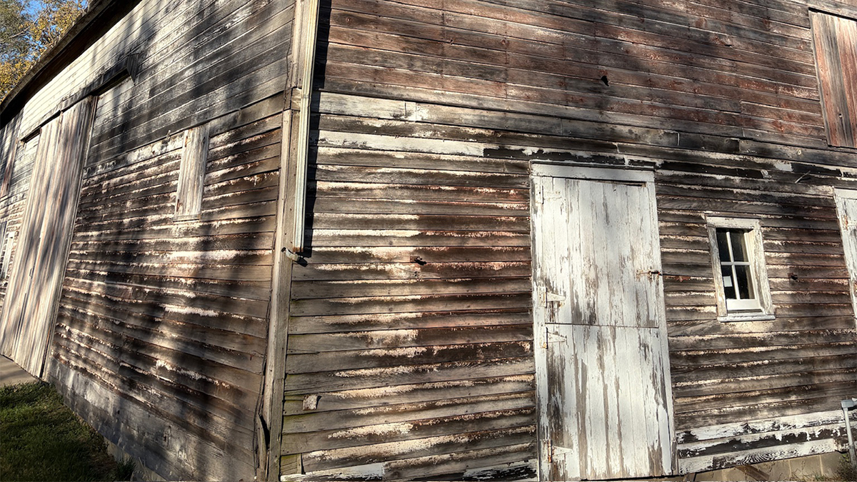
The client, Nebraska Wildlife Rehab Inc. (NWR), has a property located in Walton, Nebraska, with significant potential for future development. The purpose of this project is to create a creative and innovative Master Plan of the Walton Farm, also known as the Hegeman Herter Farmstead. This plan, to be used in a fundraising package, encompasses the restoration of a historic barn and a wetland, and the design of proposed greenhouses and aquatic wildlife caging.
The barn will serve multiple NWR functions, including a reception center, animal holding area, and classrooms. The greenhouse will be built to produce plants for food and enrichment for NWR wildlife centers. The aquatic wildlife caging will utilize a water reuse system to provide clean water for the wildlife and keep pools filled.
Jensen Park Sprayground
Team Members
- Layna Blankenship
- Lauren Flickinger
- Ashley Hernandez-Najera
- Chloe Mann
- Han Nguyen
Project Overview
Since the Fall semester progress report, the Jensen Park Sprayground project has undergone several key developments in scope, design direction, and technical analysis. These changes reflect both client feedback and a deeper understanding of site constraints. Major updates include a relocation of the project site, a reduction from three design alternatives to two, and increased coordination across engineering disciplines. The team has organized efforts into four focus areas: site design, water resources, water/wastewater, and structures.
One of the most significant changes involves the relocation of the sprayground. Initially positioned near a driveway between two roundabouts, the site was determined to present grading challenges and did not align with the City of Lincoln’s master plan, which prioritized maintaining space for future soccer fields. After consultation with the client, the project was shifted to the west side of the park within an existing parking lot area. A subsequent site visit revealed additional challenges, including proximity to a creek, potential floodplain concerns, and more complex access requirements. To mitigate grading issues, the site was further adjusted approximately 50 feet south.
The updated layout, developed in Civil 3D, incorporates contour data to better visualize grading, infrastructure placement, and retention pond siting. The new project area lies primarily on existing farmland. This introduces the need for future soil testing to confirm suitability for recreational development. Site preparation will require stripping topsoil, grading, compaction, and erosion control measures. These considerations, while outside the immediate project scope, are essential for long-term functionality and stability. From a water/wastewater perspective, the team evaluated three initial system alternatives and eliminated the basic pass-through system due to its inefficiency and strain on municipal wastewater infrastructure.
The two remaining options include a pass-through system with a retention pond and a recirculating water treatment system. The pass-through system would use potable water and direct runoff to a retention pond for reuse, such as irrigation. However, this would result in higher water consumption and limited operational flexibility. On the other hand, the recirculating system would treat and reuse water continuously. This would offer greater efficiency and control at the expense of higher construction and maintenance costs. Ongoing analysis focuses on cost, regulatory compliance, and system performance.
Water distribution assumptions have been made based on nearby infrastructure, including an estimated 8-inch water main and adequate pressure supplied by a nearby storage tank.
The proposed system will use directional drilling to minimize site disturbance and meet city standards for fire flow and pipe placement. Equipment such as spray nozzles and potential treatment systems may be sourced from specialized manufacturers. These options will be evaluated for cost-effectiveness and efficiency. Water resources analysis has advanced through runoff and watershed evaluation.
Using the methods described in the City of Lincoln Drainage Manual and TR55, the team has determined the watershed size, stormwater runoff, and proper retention pond size. Additional considerations include total water usage. Structural planning includes the design of a restroom facility with two ADA-compliant family stalls and a mechanical room. The team is evaluating both prefabricated and custom-designed options, with consideration given to cost, maintenance, and architectural consistency with nearby buildings.
Integrating the mechanical systems into the restroom structure has been found to be a preferred solution to reduce maintenance challenges and improve accessibility. Overall, the project has progressed from conceptual planning toward a coordinated preliminary design with ongoing efforts aimed at optimizing functionality, sustainability, and cost.
NDOT Maintenance Facility
Team Members
- Cameron Krueger
- Jackson Moore
- James Goeller
- Trevor Fricke
- Zach Kounovsky
Project Overview
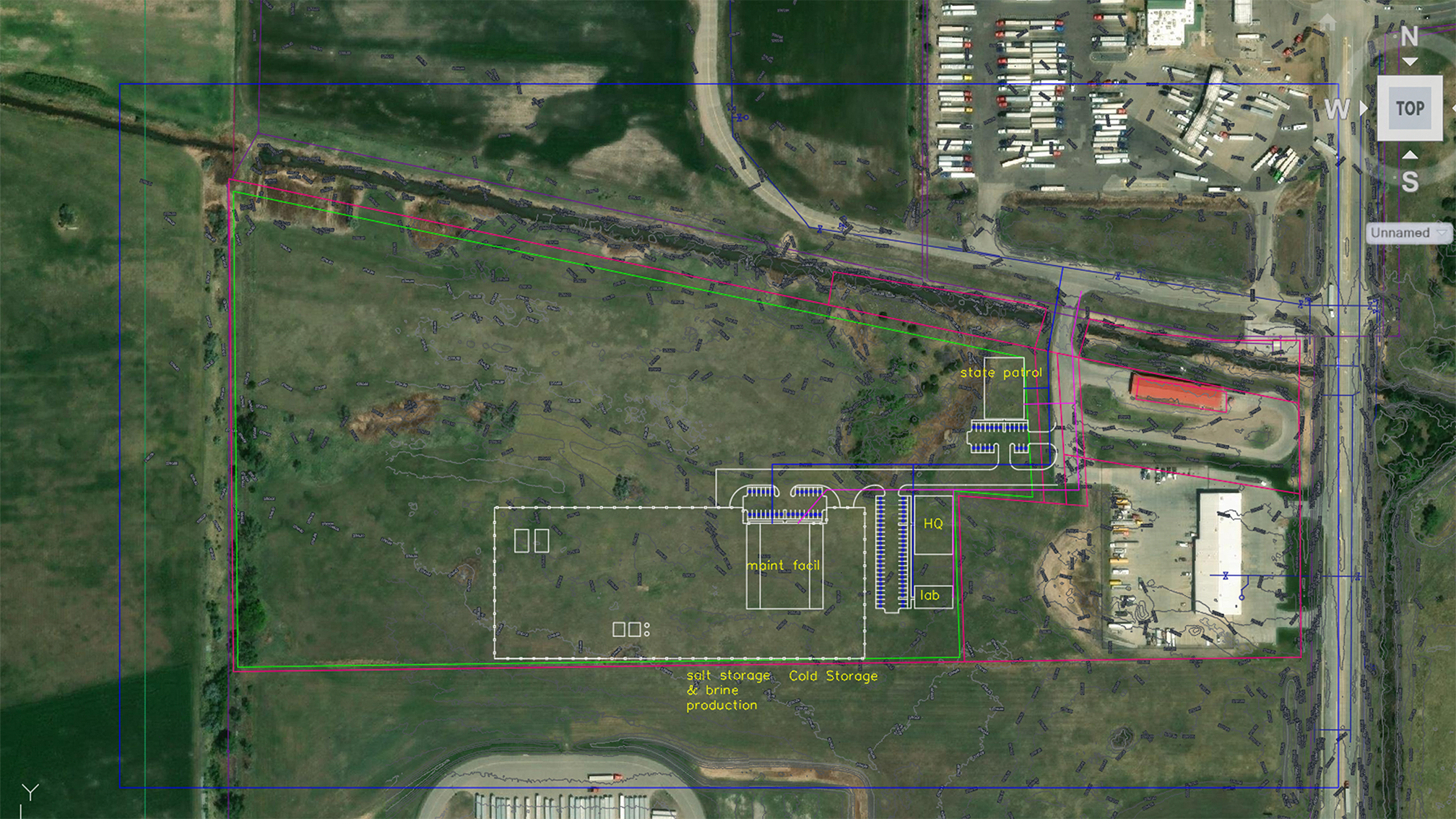
The goal of this project is to build conceptual plans for a maintenance yard in North Platte, NE, with room for future expansion. The maintenance yard will provide NDOT employees with an operations headquarters, state patrol building, garages, soil & concrete testing lab, and yard storage. The current maintenance yard near North Platte, NE, is aging and has no room for future expansion. Additionally, the closest soil & concrete testing lab is in Lincoln, NE, so building another will provide convenience for projects in western Nebraska.
Northshore Campground Expansion Project
Team Members
- Gabi Nielson
- Ellie Price
- Kodi Timanus
- Jacob Zambreno
- Matt Ziemke
Project Overview
The Snake Creek Recreation Area is a publicly owned, existing campground located 14 miles west of Platte, South Dakota. Containing 115 campsites, it boasts stunning views over the Missouri River. However, current demand exceeds the campground’s capacity causing some campers to miss out on exploring this beautiful area. In the 1960s, an expansion campground was planned to the north. However, due to budget restrictions the project was ultimately abandoned. However, our client, a contact from the South Dakota Department of Game, Fish, and Parks, stated a potential interest by the state to reconsider this previously abandoned project. Therefore, the goal of our senior design group was to design a cost effective, fully operable campground on state owned land to north of the existing campground. This new campground would serve as a beneficial public investment to foster community, inspire education, and bring more tourism to local economy. Thus, the Snake Creek North Shore Expansion project was born.
The project consisted of the three main phases. The first phase consisted of research and feasibility studies. Before any design was made, the client was consulted for data on the current campground while the potential new site was analyzed using modern software. Afterwards, iterative potential campground layouts were proposed to the client in phase two. Once the best possible campground layout was identified, the final design phase could start. This consisted of designing the drinking water distribution system, pump station, wastewater collection and management systems, road grading, storm water runoff models, and sustainability studies.
Rainwood Road Site Design
Team Members
- Calan Mikos
Project Overview
The goal of the Rainwood Road Site Design in Bennington, Nebraska, is to design a mixed-use development that integrates commercial and multi-family residential areas. The development is designed to meet all city, county, and state requirements while promoting growth principles that align with Bennington’s visions of livability and economic potential. Our work will have created a safe, efficient, and well-planned development that meets the city’s vision for future land use. Our design focuses on long-term sustainability, while also making sure the layout encourages walkability and supports the local economy through new commercial business opportunities.
W. Van Dorn Street Corridor Improvement Project
Team Members
- Evelyn Reyes
- Crishley De Leon
- Leonela Perez
- Everett Swartz
- David Alarcon
- Nick Fendrick
Project Overview
The W. Van Dorn Street Corridor Improvement Project is a comprehensive civil engineering effort focused on upgrading an existing gravel roadway into a safer, more reliable, and more efficient transportation corridor. Located in Lancaster County, Nebraska, this roadway serves as an important east–west connection between rural communities, agricultural operations, and the Lincoln metropolitan area. Due to its role in supporting both local and heavy agricultural traffic, the corridor is essential to regional mobility but currently suffers from several performance and safety deficiencies.
The existing roadway is primarily gravel, which leads to ongoing issues such as rutting, washboarding, dust generation, and rapid surface deterioration. These conditions reduce ride quality, increase vehicle wear, and require frequent maintenance, resulting in high long-term costs. In addition, a major safety concern exists where two sharp horizontal curves are positioned immediately adjacent to an active railroad crossing. This configuration significantly limits visibility and creates hazardous driving conditions, particularly for large farm equipment, during poor weather, or at higher traffic volumes.
This project focuses on reconstructing the corridor as a paved asphalt roadway designed to meet Nebraska Department of Transportation (NDOT) rural roadway standards. The proposed design includes a 36-foot roadway cross-section consisting of two 12-foot travel lanes and 6-foot shoulders. This configuration improves vehicle maneuverability, accommodates mixed traffic types, and enhances overall roadway safety. The pavement structure is developed using established engineering principles, including traffic loading analysis and subgrade evaluation, to ensure long-term durability and performance.
In addition to pavement design, the project incorporates key geometric and drainage improvements. The roadway alignment near the railroad crossing is redesigned to reduce curvature and improve sight distance, addressing one of the most critical safety issues along the corridor. Horizontal curves are designed with a target speed of approximately 50 mph, consistent with rural asphalt roadway standards, while also considering property owner constraints and right-of-way limitations. A 250-foot perpendicular approach is incorporated near the railroad crossing to improve vehicle alignment, visibility, and overall crossing safety. Vertical alignment improvements are achieved through cut-and-fill operations, which help with smoothing elevation changes and create a more consistent and stable roadway profile.
Drainage and hydrological design are also central to the project. The existing drainage system is evaluated and improved through the redesign of culverts and roadside ditches to ensure efficient stormwater conveyance. This includes optimizing culvert sizing to reduce unnecessary cost while maintaining adequate hydraulic capacity, as well as incorporating a secondary culvert where needed to improve flow distribution. These improvements help prevent water accumulation, reduce erosion, and protect the pavement structure from moisture-related damage.
From a structural engineering perspective, the project includes the design and evaluation of culvert systems to ensure they meet load and durability requirements under roadway and traffic conditions. The roadway cross section is also designed to provide sufficient structural capacity while maintaining constructability and cost efficiency. Alternative design considerations were explored throughout the project to balance performance, safety, cost, and constructability, including variations in alignment, drainage configurations, and pavement approaches such as asphalt overlay options.
Several real-world constraints are considered in the project, including environmental conditions such as severe weather, spatial limitations involving right-of-way and existing utilities, and the need to maintain access for residents during construction. The project also accounts for coordination with stakeholders, including local residents, agricultural users, business owners, and county officials, to ensure the design reflects community needs while minimizing disruptions. Overall, the W. Van Dorn Street Corridor Improvement Project integrates transportation, hydrological, and structural engineering principles to deliver a practical and sustainable roadway solution. By addressing deficiencies in pavement condition, roadway geometry, and drainage performance, the project improves safety, reduces maintenance demands, and enhances long- term reliability for a critical regional corridor